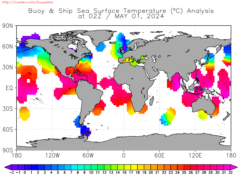
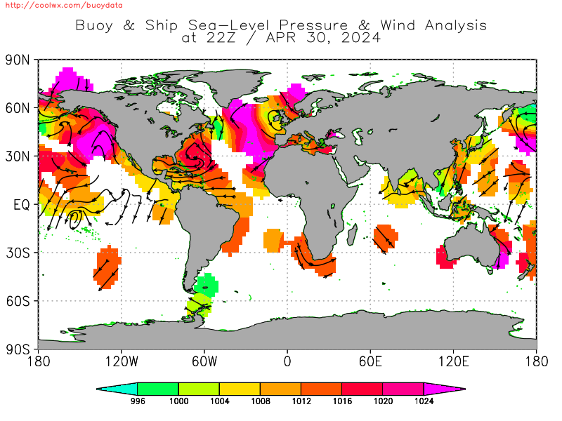
Offshore Weather Data
This web page displays decoded current and past 96hr offshore (buoy, ship) observations both in tabular format and graphically. Hurricane/Typhoon/Tropical cyclone-focused maps are also provided below. Information displayed includes sea-surface temperature, air temperature, winds, wave heights and periods, and sea-level presssure.
15 May: Important Note: Due to the increase in piracy, NOAA has been requested by the US Maritime Department (MARAD) of the Dept. of Transportation to place a significant delay on the display of ship observations in the region of the Horn of Africa and the Malacca Straits. coolwx.com was contacted directly with this request by NOAA and is complying. Ship observations from these regions will not be listed or plotted UFN.
Check the menu to your left for focused maps, text listings, or search engines.
BUOYDATA HOME
OTHER COOLWX PAGES
    Coolwx Hit Images
    Record Breakers
    Extreme Weather
    Global Forecasts
    Hourly Model Forecasts
    Mesoscale Analysis
    Obs. Weather Database
    Offshore Weather Data
    Precipitation Type
    U.S. Weather Statistics
BUOY/SHIP COUNT
TROPICAL CYCLONE/
HURRICANE-MAPS:
    93L
    NANGKA
MAPS/ANALYSES:
   
Global
   
Alaska
   
Great Lakes
   
Gulf of Mexico
   
Caribbean Sea
Atlantic:
   
NE US
   
SE US
   
Europe
   
Northern
   
Tropical
   
Southern
Mediterranean Sea
Indian Ocean
Pacific:
   
NW US
   
SW US
   
Northern
   
Tropical
   
Southern
Antarctic Waters
TEXT LISTINGS:
   
Global
   
Great Lakes
   
Gulf of Mexico
   
Caribbean Sea
Atlantic:
   
Western
   
Central
   
Eastern
   
Mediterranean Sea
   
Indian Ocean
Pacific:
   
Western
   
Central
   
Eastern
   
Other
BUOY SEARCH ENGINES:
   
Buoy/Ship Id Search
   
Lat/Lon Radial Search
   
Lat/Lon Box Search
   
Buoy/Ship TimeSeries